Water Quality
Monitoring Program Overview
The water quality monitoring program supports the District's 10-year Watershed Management Plan to remove waterbodies from the Impaired Waters list maintained by the Minnesota Pollution Control Agency (MPCA). Data collected during the field season (April to September) helps determine sources of water quality impairments and provides information needed to design and install improvement projects.
Water samples from lakes and creeks are collected manually and by automated sampling units. In-lake and in-stream sensors collect continuous data. In addition to regular monitoring sites, some locations are monitored on a rotational or as-needed basis due to project planning needs.
Data Collection
RPBCWD staff collect water quality data throughout the year. Other data is sent at the end of the year to state agencies. Water quality summaries are prepared by district staff at the end of the year.
Staff also use trusted external data sources to supplement reports. Precipitation data is pulled from NOAA, and nearby invasive species reports are reviewed in the EDDMaps to see what potential threats exist.
The figure below shows the locations of the regular water quality data collection sites in RPBCWD.
Dowload the figure of water quality data collection sites (pdf)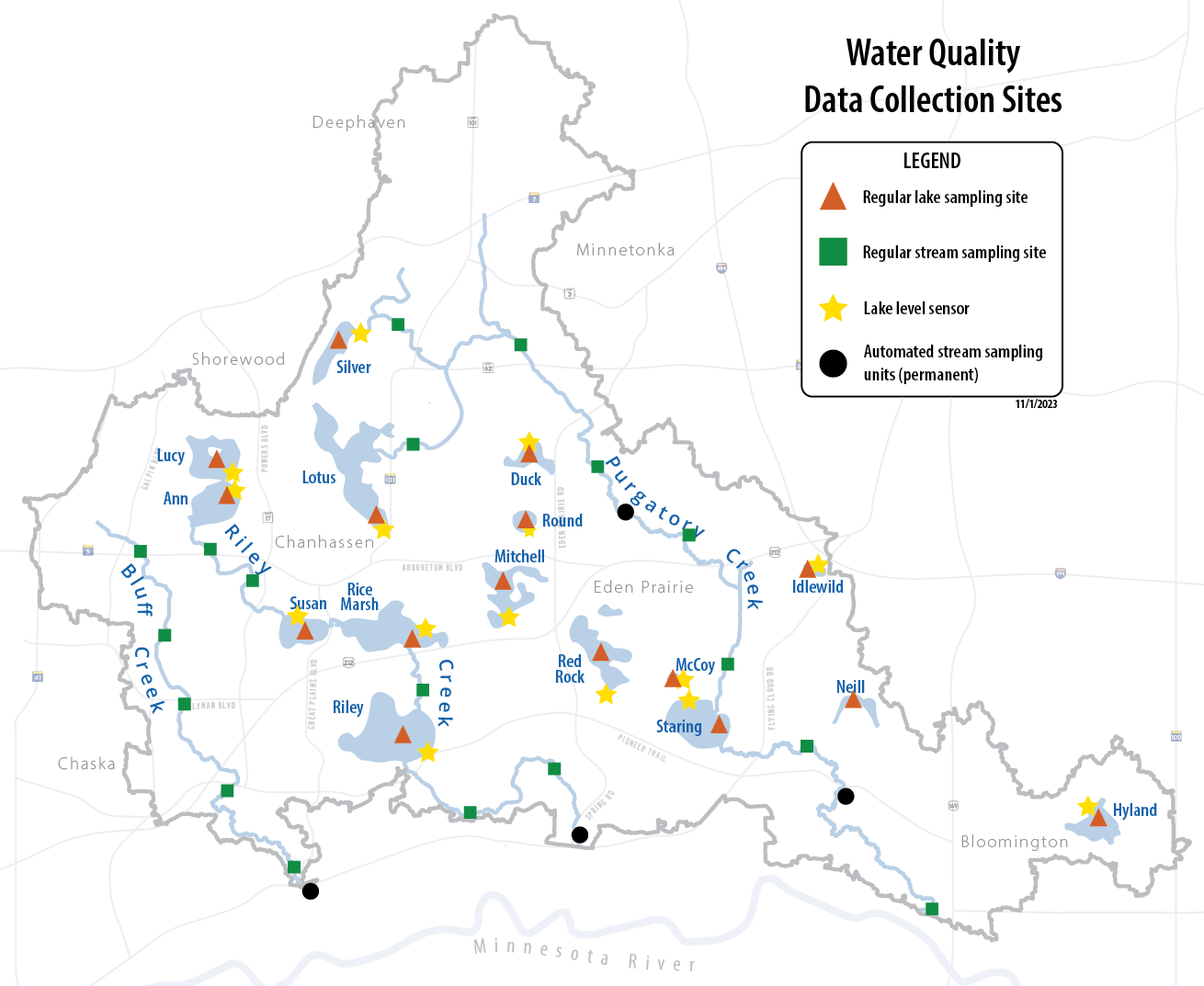
Stream Monitoring
The District monitors streams for six impairment categories defined by the MPCA. When a measured value does not consistently meet the standard, the stream is designated as impaired for the category.
Stream monitoring is an important component of the Creek Restoration Action Stategy (CRAS). CRAS is used to prioritize stabilization or restoration projects for creek reaches or subreaches.
Click the links below to learn more about monitoring results of each stream.
Lake Monitoring
Thirteen lakes are regularly monitored within the watershed district. Data collected is used to track water quality trends over time and to determine if a lake is meeting water quality standards set by the MPCA. Four lakes in RPBCWD (Ann, Lotus, Riley, and Round) are considered "Deep Lakes" and are compared to the deep lake water quality standards, which are stricter than the standards set for shallow lakes. See the table below for MPCA standards for phosphorus, chlorophyll-a, and water clarity.
| Water Quality Parameter | MPCA Standard for "Deep Lakes" | MPCA Standard for "Shallow Lakes" |
|---|---|---|
| Total Phosphorus | Less than 0.040 milligrams/liter | Less than 0.060 milligrams/liter |
| Chlorophyll-a | Less than 14 micrograms/liter | Less than 20 micrograms/liter |
| Water Clarity | Greater than 1.4 meters | Greater than 1.0 meter |
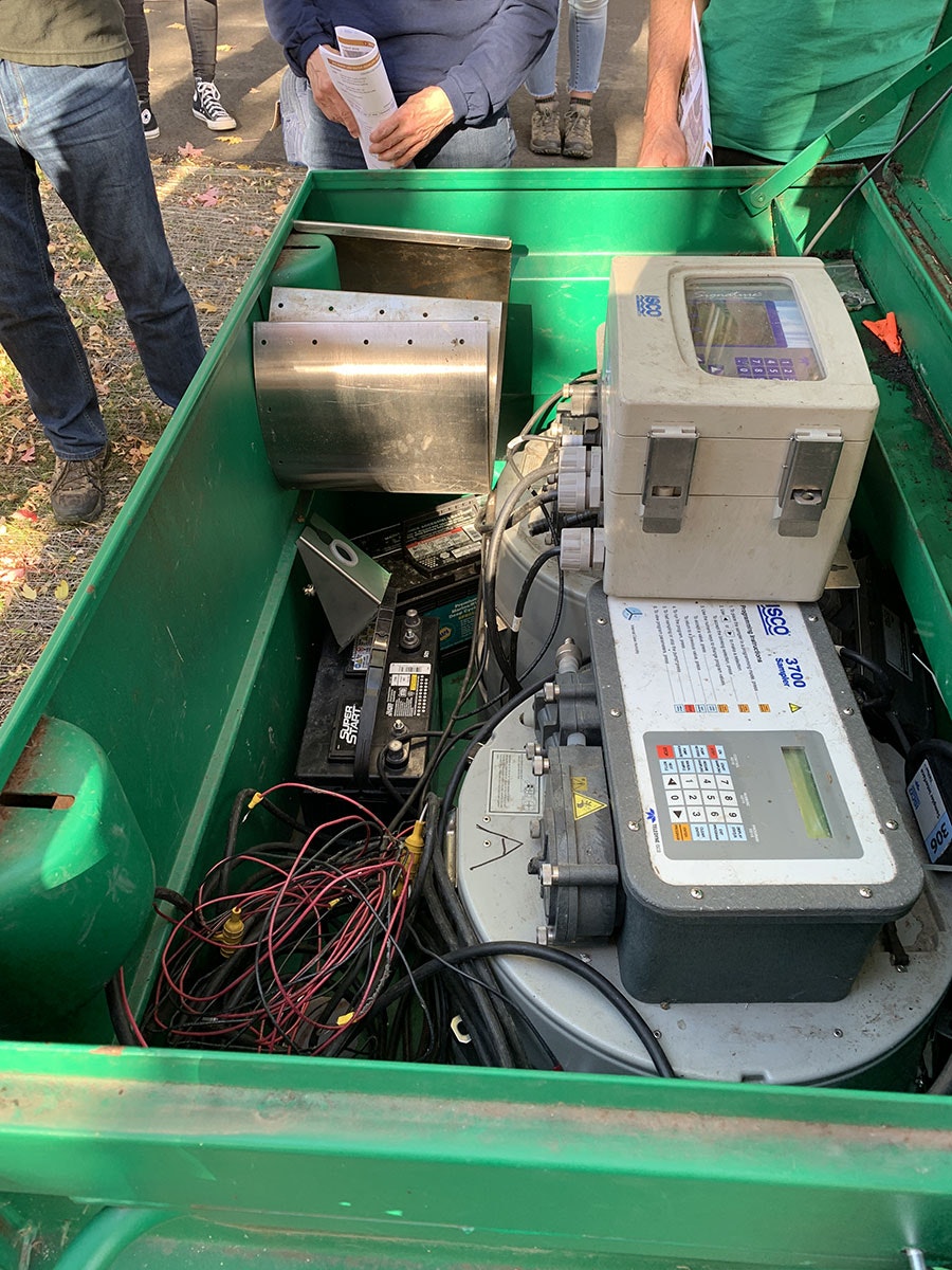
Monitoring Stations
In addition to field sampling, staff at RPBCWD place water quality monitoring stations throughout the district. The monitoring equipment is housed inside heavy duty metal or plastic boxes and includes sensors that collect data on water flow, temperature, level, and other metrics. Some of these stations also automatically collect water samples after a rain event.
The data collected is combined with other information to assess the health of water resources including streams, lakes, and wetlands. Often, the monitoring stations are placed before and after a water quality improvement project installation to measure project effectiveness.
Water Quality Reports
Staff share monitoring data through reports, presentations, and the website. The water resources is updated annually to provide a summary of water quality in the district. The factsheets are also updated annually and provide lake and stream-specific water quality information.
- Water resources reports - Read the most recent and previous water quality reports.
- Lakes and creek webpages - Find information about each major waterbody on our website.
- Factsheets - View factsheets for lakes and streams including water quality data summaries. Printed copies are also available at the RPBCWD office.
Monitoring by Others
These organizations also collect and/or analyze water quality data:
- MPCA Water Quality homepage
- DNR Water Quality - lakes
- DNR Watershed Health Assessment Framework (WHAF)
- Carver County Water Quality